The Picts: Ancient Visitors to New Hampshire?
By Marc Roland
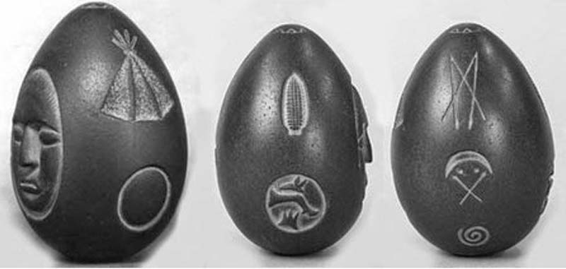
On an early autumn morning during the late 19th century, workers were excavating a hole for a fencepost in the rural New Hampshire town of Meredith. About six feet down, their shovel brought up a heavy, peculiar-looking lump of clay. Inside it, they found an even stranger, egg-shaped stone, one side skillfully carved to resemble a human face. On its right appeared the representation of an upright ear of corn with seventeen kernels above a circle enclosing the likenesses of a rabbit, the foreleg of a deer and a less identifiable crown-like image. On the opposite side from the face appeared a composite glyph of the capital letters M and X. Beneath these was a crescent surmounting two dots and a pair of crossed arrows above a spiral. To the left of the face was the likeness of an Indian teepee over a circle. An eight-rayed figure appeared at the very top and bottom of the stone.
All its images were created by engraving them into the surface, a process known as “counter-relief,” distinct from “relief.” For example, the face, like the other intaglios, is sunken, with the tip of its nose conforming precisely in line with the object’s curved exterior. Sculpting it was no easy task, because the article is as hard as granite, made of mylonite, a fine-grained metamorphic rock derived from sandstone, a type of quartzite formed by seismic transference of subterranean rock layers along fault lines. The stone had to have been imported from far beyond New Hampshire because mylonite is not native to New England.
The size and shape of a goose egg, the dark-brown piece is about four inches long, two and one-half inches thick, and weighs 18 ounces.
The fencepost workers brought their find to the distinguished citizen who hired them, Seneca Augustus Ladd. As founder in 1869 of the Meredith Savings Bank (still in operation today), with membership in the New Hampshire Antiquarian Society, State Historical Society and Massachusetts’ Pilgrim Society of Plymouth, he was never suspected of having faked the object as part of some hoax. On the contrary, the discovery was described as an authentically prehistoric artifact by the mainstream journal American Naturalist in its November 1872 issue, and the director of Washington, D.C.’s Smithsonian Institution asked Ladd to make a plaster cast of the stone for the American Antiquities Museum.
Following Ladd’s death in 1892, his daughter, Frances Ladd Coe, inherited the item, donating it 25 years later to the New Hampshire Historical Society, today the Museum of New Hampshire History, in Concord, the state capital, where it is now publicly displayed. While the American Naturalist article’s described it as “a remarkable Indian relic,” curators at the Museum of New Hampshire History separated the Winnepesaukee Stone from their Native American 1800’s-era cultural artifacts. “It may very well have been the work of someone living in a faraway place and time,” wrote Brian Hill in August of 2015 for Ancient Origins, “as nothing like its fine workmanship has been produced by [North] American tribes living locally in the area. . . . There are no other known objects bearing similar markings or designs in the United States.”1
Although they have eluded understanding for the last 143 years, their closer scrutiny within the New Hampshire find’s geographical context clearly reveals its origins with a people remembered as the Picts. The name was applied to them by 1st century Roman occupation forces in Britain, where native warriors from the north often tattooed their bodies with ornate, colorful designs, a practice that gave rise to the word Picti (from the Latin pingere “to paint,” or pictus, “painted”) for a “painted or tattooed people.”
While “Picts” was a generic term for indigenous inhabitants north of the Forth-Clyde Isthmus, they more probably referred to themselves as the “Albans” or “Whites.” The original title of the Pictish Chronicle was the Duan Albanach, and the De Situ Albanie references much of Scotland as “the Kingdom of Alba,” or “Kingdom of the White People.” Even in modern Gaelic, the name for Scotland is Alba , “White Land.”
In the myths of ancient Britain, its first monarch was Albion, titan brother of Atlas, the eponymous king of Atlantis. Alba , or “Pictland,” as the imperial Romans called it, was a confederation of tribes residing in what is today eastern and northern Scotland, including some of the Orkney Islands. The Picts were ethnically and linguistically Keltic, but distinct from all their kinsfolk occupying the rest of Britain, because they melded with earlier, resident megalithic culture-bearers.
This amiable amalgamation is referenced by several Ogam inscriptions in local, unknown languages spoken by stone age indigenes. Native to the British Isles, Ogam was an ancient alphabet, consisting of 25 or so characters formed by parallel strokes on either side of or across a continuous line. Scotland’s Neolithic and later Bronze Age societies were less than remnant cultures by the 6th century B.C., when Keltic immigration from the European mainland began, but at least whispers of their former “big stone” construction techniques and achievements in astronomy lingered on, however attenuated, to influence Pictish development.
Most Picts were Iron Age metallurgists and farmers, but many were skilled shipwrights and renowned sailors: “The Picts are associated with piracy and raiding along the coasts of Roman Britain. Pictish pirates were probably merchants on other occasions.” Archeologists have found “evidence of long-distance trade with Pictland, tableware and storage vessels from Gaul, probably transported up the Irish Sea. . . . While long-distance travel was unusual in Pictish times, it was far from unknown, as stories of missionaries, traveling clerics and exiles show.”2
Common themes in surviving Pictish art include numerous depictions of sea creatures, particularly the dolphin, from which the Albans claimed descent, and kelpies, water spirits in Scottish folklore, typically taking the form of a horse.
The earliest surviving records of the Picts go back less than 2,000 years, during their first clashes with the invading legions of Roman Emperor Hadrian. He built the famous wall in his own name as an attempt to protect Roman-controlled Britain from Pictish attacks. It held them back for the next three centuries, although it likewise indicated the farthest northern extent of imperial ambitions.
The Kingdom of Alba was eventually brought down, not by external foreign aggression, but through internal discord fomented by proselytizing Christians exploiting inter-tribal rivalries on behalf of religious conversion. Not long after the end of the 10th century, Pictish identity had been subsumed in a Gaelic confusion of numerically overwhelming outsiders, who knew little and cared less about the sinfully “heathen” Kingdom of Alba.
If hardly more is known concerning the Picts, that is because “Pope Gregory in the 6th century decreed that all pagan statues and temples be destroyed in Britain and replaced with Christian churches.”3
The only artifacts surviving after more than a millennium of material Pictish culture are fewer than 300 engraved stones, most of them fragmented. Recurring among these broken pieces is an equivalent of the Picts’ national emblem: a crescent on its side intersected by an 80-to-85- degree chevron.
The meaning of this unique if ubiquitous symbol was lost until a few years ago, when Canadian archeoastronomer, Jason Nigel Bellchamber, proved that it is a celestial marker indicating (with the right arrow) 15 to 20 days after the spring equinox, and (with the left arrow) 50 to 55 days following the fall equinox. These intervals define, respectively, the agricultural time span in northeastern Scotland, where the growing season begins and ends in the periods specified by the crescent and chevron. Without knowledge of these date parameters, farming at latitudes of 56.5 north to 59 degrees north, the geographical location of ancient Alba, would not have been possible.
Bellchamber explains how “the Pictish farmers also knew how to use lunar cycles to plant and harvest with,” as suggested by the crescent moon in their ideogram. “A full Moon makes the ground moister, and a new Moon will make it drier.” He cites a section in the Old Farmer’s Almanac, “Planting by the Moon,” which told of agricultural folk procedures deeply rooted in prehistory: “Above-ground crops are planted during the light of the moon (new to full); below-ground crops are planted during the dark of the Moon (from the day after it is full to the day before it is ‘new’ again).”4
These nocturnal methods, not typical of Keltic farmers elsewhere, were likely adopted from local, Neolithic predecessors, who originally obtained such information from the astronomical alignments of their standing stones, and doubtless passed along to the Pictish newcomers supplementary astroagricultural tools like the Crescent V-rod. That it reappears on the Winnipesaukee Stone can only mean that visitors from Northern Europe arrived in pre-Columbian North America, as denoted by the depth at which the find was made and its iconic symbol. Its only discrepancies from the Pictish version are the addition of two dots and lower placement of both arrows, indicating the latitudinal difference in planting seasons between Scotland and New Hampshire.
Other images on the surface of the artifact repeatedly underscore its Pictish identity. Above the crescent with arrows is an X connecting a pair of vertical strokes. Placed on its side, this glyph is a variant (there were many such variations in Alba) of another Pictish ide- gram, known as the “Z-rod.” Although its meaning is unknown, it appears to have had astroagricultural significance, like the more common Crescent V-rod A spiral, universally associated throughout Western antiquity with the movement of a heavenly body, is engraved beneath the crescent with arrows. Its celestial alignments, Bellchamber states, were determined by a megalithic circle oriented to the North Star, which is depicted at the very top and bottom of the Winnipesaukee Stone with eight rays. Numerous seafaring cultures in the ancient Old World identified this number with Polaris. The Phoenician name for the North Star, Eshmun, means “the Eighth.”
After 1900 B.C., Thuban lost its place as the Pole Star in dynastic Egypt. “Anup, the highest power at the Pole, then becomes arranger of the stars,” as “the eighth . . . said to fix the places of the seven glorious ones [the stars as gods].”5
“The [North Star’s] eight lines are symbolic of the four corners of space—north, south, east and west—and time: two solstices and two equinoxes.”6
The face on the Winnipesaukee Stone bears a resemblance to the Keltic lunar deity, Andraste. Her identity is affirmed by a blank circle self-evidently signifying the full Moon, which, as described above, was critical to Pictish agricultural practices. Like other lunar goddesses (the Etruscan Losna, Greek Artemis, Roman Diana, Mayan Ixchel, Pawnee Pah, Navajo Yoolgai asdzaa´ et al.), her avatar and constant companion was the rabbit. Its image appears in a circle on the New Hampshire object above the representation of a deer’s severed foreleg, symbolizing the hunt, of which Andraste was the divine patroness. Beneath it is nothing less than a Pictish glyph, its meaning unknown.
Over the trio of encircled ideograms stands an ear of corn parallel to the rendering of a typical Plains Indian teepee. The appearance of these North American images among identifiably Pictish elements recalls 1872’s American Naturalist article, which suggested that the Winnipesaukee Stone “commemorates a treaty between two tribes,” one of them from the other side of the world.7
Indeed, the depicted corn may tell us why the Picts undertook such a long, hazardous voyage. They were a farming people struggling to scratch a living from Scotland’s rocky, difficult soil, and undoubtedly experienced severe periods of under-productivity. Occasional desperation caused by such food shortages may have tempted them to sail to North America for relief. Roman occupation of Europe and, later, tribal rivalries with other Keltic groups in Britain and on the continent left the Picts only with a transoceanic option. Arriving on the Atlantic shores of what is now New Hampshire, they struck up an agreement of some kind with its native inhabitants, who loaded the Picts’ ships with enough corn to at least alleviate conditions back in the homeland, far across the sea.
In light of the Winnipesaukee Stone’s superior craftsmanship, unlike anything of the kind produced by pre-Columbian American Indians anywhere, it was prob- ably carved by one of the visiting Picts, who presented it to the Indians as a token of cooperation between their two peoples. More specifically, the object is a Glainnaider, or Glain-nan-Druidhe, Gaelic for “Druid’s Glass.” The Druids were priests and soothsayers of the ancient Keltic religion, and a
Glainnaider was part of their magical kit. The renowned Scottish mythologist of the last century, Lewis Spence, describes it as an “ornament, which the Druids were wont to carry suspended from their necks as a mark of their office [which may explain controversial holes drilled at either end of the Winnipesaukee Stone].”8
The Glain-nan-Druidhe was also referred to as the Serpent’s Egg, because the Druids were additionally known as Nadredd, or adders, symbolic of their powerful, mysterious wisdom. “The Serpent’s Egg is a so-called oval ball of crystal [the Lake Winnepesaukee Stone is quartzite]. He who possessed it was certain to gain any lawsuit in which he might engage, and would be ‘well received by kings’,” useful when negotiating with Indians for corn. “In many parts of Wales, Scotland and Cornwall, people retained superstitious ideas concerning the origin and virtues of these ‘eggs’.”
Lake Winnipesaukee derived its name from an Algonquian-speaking people notable for growing corn along fertile central New Hampshire river beds. Before their extermination at the hands of other Indian tribes during the first half of the 18th century, the Winnipesaukee were portrayed with somewhat European facial features—perhaps resulting from ancient liaisons with Keltic visitors—by Colonial sketch artists, who additionally reproduced the tribe’s singular headgear, which bore a striking resemblance to a Phrygian cap. {See facing page.—Ed.] This conical cap with the top pulled forward originated in and was forever afterward associated with Phrygia, an Indo-European kingdom that flourished in Asia Minor—modern west-central Turkey—2,700 years ago.
Coincidentally, the Picts claimed their earliest ancestors came from the Thracian Sea, the extreme northern part of the Aegean Sea that includes Asia Minor’s west coast. The 5th century B.C. Greek historian Herodotus of Halicarnassus wrote that the Phrygians were, in fact, Brygians, the inhabitants of Thrace, roughly corresponding to modern Bulgaria, on the northern shores of the Aegean.10
“Brygia” and “Phrygia” are variants of the same root-word. These Brygians/Phrygians migrated during the chaotic, final years of the late Bronze Age, circa 1200 B.C., into the southern Balkans from Asia Minor. At least some of them traveled farther to Scotland, where they adopted local Keltic and Neolithic customs to become the distinctive Picts, a harmonious blending of three Aryan peoples.
In any case, Meredith, where the Lake Winnepesaukee Stone was found, is bounded to the northeast by Lake Winnipesaukee, which is accessible to the Atlantic via the Winnipesaukee River flowing west from the lake to join the Pemigewasset River, running south to Massachusetts and into the ocean. Pictish seafarers arriving on the eastern seaboard would have enjoyed a direct passage to Lake Winnipesaukee. At a strategic fork of the Pemigewasset and Winnipesaukee rivers, near the town of Sanbornton, “is a remarkable structure for New England,” observed Sourcebook editor, William R. Corliss, “quite out of place,” because it is an ancient, hilltop fort.11
The emplacement was mentioned as long ago as 1822 by surveyor J.B. Moore, who described the massive walls as “about three feet in thickness, constructed of stones outwardly, and filled in with clay, shells, gravel, etc from the bed of the river and shores of the bay. . . . They were placed together with much order and regularity, and when, of their primitive height, the walls must have been very strong, at least sufficiently strong for all the purpose of defense against an enemy to whom the use of firearms was unknown.”12
Corliss adds that “the width of the U-shaped, double-walled structure was 250 feet, north to south. When the first European settlers arrived, they found large oak trees growing within the fort,” indications that it had been abandoned at least as long ago as A.D. 1400. “Besides stone arrowheads and hatchets, they also picked up crystals cut into the rude shapes of diamonds, squares, pyramids etc,” uncharacteristically American Indian, but reminiscent of the Druids’ crystal Serpent Eggs.13
Sanborton’s prehistoric military installation was a mirror image of hillforts operated by the Picts. Not only were the same building materials and methods, as reported by Moore, used in both New Hampshire and Scotland, they were assembled at the same time, between A.D. 100 and 500. The otherwise unique U-shape he found outside Sanbornton recurred only in Pictland, mostly below the Clyde-Forth line. A U-shaped, 20-acre enclosure dominated the East Lothian valley of Traprain Law until farmers dismantled it in the early 19th century, but modern climbers to Ben Macdui may still see the U-shaped ruins of the highest hillfort ever built at Ben Macdui, at 4,294 feet, the second tallest mountain in Britain after Scotland’s Ben Nevis. According to Scottish reporter Alexandra Henton, the U- and “V-shaped ditch and bank [are] typical of Iron Age hillforts.”14
As the third-largest body of fresh water in New England, Lake Winnipesaukee is almost 21 miles long (northwest to southeast) and from one to nine miles wide (northeast by southwest), covering 69 square miles. Of its 258 islands, two are pertinent to our discussion. Forty-four years ago, Leon L. Morrill Jr. explored remote, seldom-visited Ragged Island: “Here is a monolith bearing a series of pit or cup marks lines up with two other nearby boulders on both the winter and summer solstitial sunsets. On Sandy Island, southwest of Ragged Island, is another monolith, which —if the present trees were removed to open the view—could be seen from the first monolith, and might line up with a further sighting point on the horizon.”
And, Morrill adds, “the cup marks on the first monolith are of special interest, recalling the numerous cup-marked stones in the British Isles.”15
If the Picts landed in what would much later become New Hampshire, they were not the first. Sixty miles south from Lake Winnipesaukee lies “a group of chambers, underground passages, alignments and inscriptions” dated to circa 4580 B.C., in the town of Salem, as described by Bruce Scofield, Ph.D., a faculty member at the University of Massachusetts.16
Known as America’s Stonehenge , “its construction is quite reminiscent of the Neolithic village of Skara Brae in the Orkney Islands of Scotland,” observed archeologist Dr. David Zink.17
Ancient American writer James Vieira tells how “stone markers throughout the site provide over 200 alignments with the Sun, Moon and 45 different stars, which have been verified by independent researchers.”18
America’s Stonehenge was raised by the same Neolithic Northern Europeans from whom later Keltic arrivals learned applied astronomy and about another continent on the other side of the ocean.19
As such, the Lake Winnipesaukee Stone is a testament to the transatlantic courage and cultural greatness of our Iron Age European ancestors.
Endnotes:
1 Hill, Bryan. “Out of Place Artifact: The Mysterious Stone Egg of Lake Winnipesaukee.” www.ancient-origins.net/unexplained-phenomena/out-place-artifact-mysterious-stone-egg-lake-winnipesaukee-003622, August 2015.
2 https://en.wikipedia.org/wiki/Picts.
3 Bellchamber, Jason Nigel. “The Pictish Symbol Known as the ‘Crescent V-rod’ and Its Possible Use as a Seasonal Sundial or Farmers Almanac.” http://www.bellchamber.net/Publication/The%20Pictish%20Crescent%20V-rod%20as%20a%20Seasonal%20Sundial%20by%20Jason%20Bellchamber.pdf.
4 Ibid.
5 Massey, Gerald. The Sign Language of Astronomical Mythology, Montana: Kessinger Publishing, 2005.
6 “Origins and Meanings of the Eight-Point Star.” http://moroccandesign.com/eight-point-star.
7 Hill, op. cit
8 Spence, Lewis. Magic Arts in Celtic Britain, 1946. https://siderealview.wordpress.com/adderserpents-egg-or-druids-glass-by-lewis-spence/.
The Winnipesaukee Stone was avoided by conventional archeologists until 1994, when they investigated its separate holes—each one straight, not tapered, drilled one-eighth inch at the top and three-eighths inch at the bottom—bored through from end to end of the artifact. Although borescope examination suggested that the holes were drilled using steel drills, this news had no real bearing on the identity of the object itself. Neither did scratches noticed in the lower bore, which appears to have been placed on a metal shaft and removed several times. Seneca Ladd, his daughter Frances, or someone else in his family could have tampered with the object, although there is no record of anyone ever having done so. Or, if the holes were not made by American Indians, who only used fire-hardened wood dowels for drilling in material less hard than mylonite, perhaps more technologically advanced Pict metallurgists, well-known for their “fire-steel”—- high-carbon or alloyed steel from which sparks are struck by the sharp edge of chert or similar rock—were responsible.
9 Spence, op. cit
10 Herodotus. The Histories. New York: Penguin Classics, 2003.
11 Corliss, William R. Ancient Structures. Maryland: The Sourcebook Project, 2001.
12 Squier, E.G. Aboriginal Monuments of the State of New York. Washington, D.C., 1849.
13 Corliss, op.cit
14 Henton, Alexandra. “Iron Age Hillforts.” www.thefield.co.uk/features/iron-age-hillforts-21556, May 8, 2012.
15 Morrill, Leon, L. Jr. “Possible Megalithic Alignments in New England.” NEARA Newsletter, 6:15, 1971.
16 Scofield, Bruce, Ph.D. in Sacred Sites. Minnesota: Llewellyn Publications, 1992.
17 Dr. David Zink in Before Atlantis, Vermont: Bear and Company, 2013.
18 James Vieira. Ibid
19 The 48-page booklet The Mysterious Megaliths of New England (softcover, illustrated) by Paul T. Angel is available from The Barnes Review for $8 ppd. inside the U.S. from TBR, P.O. Box 15877, Washington, D.C. 20003. Call TBR toll free 1-877-773-9077 Mon.-Thu 9-5 to charge. (Outside the U.S. please email sales@barnsreview.org for foreign S&H.) Bulk quantity prices of this booklet are available.
CAPTION:
The Winnipesaukee Stone on display at Concord’s Museum of New Hampshire. Top left: Behind the face of Andraste—the Picts’ lunar goddess, divine patroness of the hunt—a circle encloses descending images of a rabbit (her symbolic companion), a deer’s foreleg (signifying the hunt itself) and a Pictish glyph. In the oval above stands the representation of an ear of corn. Top above: a blank circle for Andraste’s full moon floats beneath an Indian teepee. Bottom above, in order of appearance, is the Picts’ astronomically derived “Z-rod glyph,” their characteristic “Crescent V-rod glyph,” and celestial spiral.